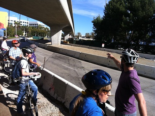
This past Sunday members of the Expo Bicycle Advisory Committee (Expo BAC, of which I am a member), and a few members of Santa Monica Spoke, rode the length of the Expo phase II corridor led by Stephen Villavaso, an engineer on the project who works for Skanska-Rados and who wears a bike advocate hat for the CicLAvia board. This was much like a similar ride last year to see the sites in person.
The bikeway design is partially completed, but there are a few details and questions remaining to be ironed out. Further complicating things, there are transitions and gaps that are outside of the current Expo project scope, but are to be filled in by LADOT, such as the Northvale corridor. It’s been quite a transformation along the route since that last get together, when major infrastructure like the bridges were diagrams on paper, and now most of them are nearing completion, and segments of finished rail are in the ground.
The bike route is shaping up quite nicely in parts, and a few areas of initial safety concern by the Expo BAC have been addressed in design changes, or pending design changes. However, I still wish this process had begun before so much of the rail infrastructure design was finalized, and the options constrained by rail facility design. For the sake of at least a small nod to brevity and calling attention where it is most needed, I’m going to focus on the areas and issues where I have the greatest concern for realizing the full potential and functionality of this route as a facility safe for users of all ability levels, and the convenience for future cycling travelers along the route.
View Expo Phase II bikeway in a larger map (and to see color coding key)
Starting from the beginning of our ride, at the section of class 1 path that begins at La Cienega and connections to Ballona Creek path, and heading westbound, there is a sizable gap between the Phase I, class 1 bike path and where the Phase II path will begin. Basically, the Culver City station and what is currently it’s surface parking lot (slated for future redevelopment) sits in the middle of the gap. This area is technically outside the scope of the Expo Line Phase II project itself, but will need to be addressed to create a seamless link to the existing path connection to Ballona Creek, and improving the ride up experience to both the Culver City (current terminus stations) and the La Cienaga station.
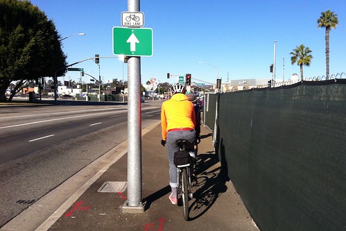
Along the western end of the existing class I path, we’ve been left with an unfortunate and awkward dilemma where the path dumps carelessly into a narrow sidewalk. Existing signage both declares the stretch as part of a bike route, and prohibits bicycling on sidewalks. There is no curb ramp, so to be in the letter of the law, you can jump off the curb and ride the roadway on fast moving National Blvd, or you can step off the bike and walk half a block. Of course we rode on the sidewalk there anyways, as anyone encountering the same circumstances would do.
Then we crossed two crosswalks to get to the station parking lot, which we rode through. It wouldn’t have been hard to stripe a simple cycle track adjacent the station curb, that could keep cycling separated from both the walkway leading to the station, and from any interactions with cars in the parking lot. There is no shortage of space, but of course no such consideration was given when the lot was freshly paved and re-striped.
Then there is crossing Venice to get to the entrance of the proper start of class 1 bike path being constructed for Phase II of the project. Way finding will be vital to ensuring people can make these connections smoothly and easily at environments with lot of possible options and things going on. Moving on from there, the first section of Phase II path has a short jaunt between the rail retaining wall descending to ground level and tall blank walls of building right to property line edge, one of a few short stretches in a constrained canyon like space. Not much can be done about the built environment being less than ideal here, but ensuring adequate lighting is installed for visibility will be important.
From there the path runs adjacent Exposition Ave. in a residential area, with homes across the street to the south, and the train right of way north. The primary area within the Phase II corridor (but outside the Expo construction authority scope) that has significant undecided aspects are the segments east of Palms/National to Overland Ave. to the West. From Palms/National onto Motor, LADOT will oversee on-street bikeway facilities. At a minimum this could be standard bike lanes to fill the gap to the contentious Northvale corridor.
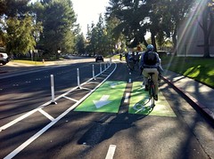
Upon riding through the corridor again, I believe the road width exists that a physically protected 2-way cycle track on the north side of the street on National may be feasible with a relative minimum of potential conflicts across the bikeway as there are very few driveways and long block lengths. From National the routing will go up Motor to the proposed path corridor on the easements that connect to Northvale minus the steeper hills and extra distance routing around would have required. The tunnel under the freeway for the trains is barely wide enough to fit the trains, with no room to spare for a bike path, so that was off the table for connecting across to the north side of the freeway. I recall Motor being pitched as having bike lanes with a new bike and pedestrian crossing at the path continuation, but there was some talk on the ride of doing a 2-way cycle track on Motor, a short stretch without intersections conflicts.

There are contexts in which 2-way cycle tracks can be problematic, but for these limited stretches with few or no conflicts, to bridge gaps with class 1 facilities with both directions of travel together, they may be the best way to go, and offer greater real and subjective safety. When I was in Davis in California, I experienced riding in a 2way cycle track for just such a similar context of connecting to bike path and avoiding making an unprotected mid-block left turn.
As for the Northvale corridor itself (in yellow on the map for easement behind homes, magenta on Northvale, both LADOT) a lot remains up in the air and the presentation I saw in September from Michelle Mowery and LADOT at a meeting in Cheviot Hills, general lines for routing were shown but no visual details, soliciting feedback but not offering up anything to really look at. At that meeting a timeline was shown, most likely influenced by the trepidation the prior lawsuit has triggered, that showed construction in 2015 for an opening date in 2017 for the Northvale segment. It was hard to contain my extreme disappointment at a pathetically drawn out date that would leave a sizable gap in the middle of the route without any bikeway, well past the opening of the rest of the path and the Expo Line beginning train service. The Northvale corridor section of the route is definitely at the top of my list of concerns on the project with so much unknown, community resistance beyond anything found elsewhere in Phase II, LADOT in charge, and such a sad timeline already presented.
For more detailed photography of the Northvale corridor and easement area, this post on the Transit Coalition forum is an absolute gem, and other posts in the thread have many detailed images of other aspects of the Expo Line project.
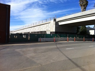
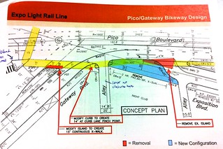 Once through Cheviot Hills, the path is pretty straightforward and uneventful until you get to the 405 Freeway and the crossing of Pico Blvd. Here there is a constrained space between bridge pylons and a wall from storage facilities on property adjacent the right of way, another site where not much can be done about the built environment, but providing adequate lighting and other features will be important so it doesn’t become a dark corridor. At Pico itself, we have the formidable challenge of a complex high traffic volume intersection with non-perpendicular streets, and multiple crosswalks for anyone not comfortable with a “vehicular” style crossing, or doesn’t get off the path at an earlier point and riding on Pico.
Some design tweaks have been proposed to improve this somewhat. My own idea proposed for a diagonal bike only signal Phase that could be triggered and vastly simplify this situation, was pretty swiftly shot down, as anything that might dare effect green time for vehicular traffic Phases is out of consideration. As I wrote on Phase II issues before, even when we are designing for mobility beyond cars, the car is often still centralized.
On the matter of Centinela (where the border of Santa Monica and city of Los Angeles meet), a crossing that has been controversial since before the Expo BAC was formed, and which was one of our early high priorities, there is some good news. For background, the crossing was controversial due to the fact it was originally proposed by the construction authority as crossing at an “L” and across a driveway entrance to the future maintenance yard for the Expo Line and with poor sight line visibility, and was opposed by planners from the city of Santa Monica.
Now a new design, pending a few more details we’re hopeful with be ironed out on financing, is moving forward that would shift Exposition northward slightly at the intersection, allowing a crossing that would go straight across to the path and avoid entirely the driveway ramp. This has been one of the bigger wins of the bicycle advisory committee process, and our insentience the prior design represented a needless comprise of safety and quality of connection between Los Angeles and Santa Monica.
Once in the city of Santa Monica, I have fewer serious concerns on the route, and a much greater trust that the city planners have already been on top of addressing issues for the path design and interface with the city. There is the long corridor between studios and the maintenance yard that is a another “canyon” concern area, but the latest I’ve heard is the Lantana creative studio and office campus is planning on opening access points of their own for the path, which would be to the benefit of their employees as well the public. At Olympic we have the issue of new crossings that make use of the median space to break up the crossing into two Phases for each direction of traffic, which is unusual from other crossings on the route, but should make crossing Olympic easy and safe to do.
The path will terminate at 17th St., where bicyclists will connect to Santa Monica’s bike route network. If they wish to continue westward, will have the choice of heading south to the Michigan Ave. Neighborhood Greenway now in planning stages, or north to Broadway, which for now features standard bike lanes, but is slated for soon for “buffered” space and a more visible green paint job. 17th itself is standard bike lanes now, but in the bike plan, and the in the developing Memorial Park area plan, is slated for protected bikeway or cycle track type of facility to connect to Santa Monica college.
So that’s my rundown of the route, focusing on where my biggest concerns are, but we’re definitely making progress to better design outcomes than when BAC involvement existed, and if the broader cycling advocacy community is looking for places to apply pressure or do outreach for further improvements, hopefully this post outlines where it’s needed most. That the timeline for the Northvale section has been pushed back so far, is definitely my greatest concern right now, since it’s absence right in the middle diminishes the functionality of the route as complete whole, one at a “class 1” level of quality, quite substantially.
The full set of the photos I took on the ride can be found here, and all the images are geotagged and can be displayed on the map feature. If you have any specific questions, feel free to leave them in the comments and I’ll try my best to fill in what I know or at least where to direct further inquiry to.